
Friday we went hiking with our friends Jessie,
Renalee, and
Rese in Queen Valley. We drove 11 miles into the mountains over dirt road before reaching the trail head. The trail winds 6 miles back to an old orchard. We only made it about 4 miles and then had to turn back in order to make it back before dark. This was a different hike from the others I have experienced in Arizona because there were lots of streams as well as trees. The air was cool in the morning when we started out and it reminded me so much of Michigan. I even found a Michigan map located on one of the Prickly Pear Cactus.


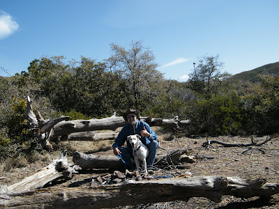
Jay and I at the start of the hike when the feet were still fresh. It had 4 layers to start and slowly shed them until I was down to a single layer.

Lots of interesting nature to explore.


I decided it would be a good idea to take pictures of the pretty rocks instead of trying to carry them all. I did carry back a Geode and a piece of sparking Mica that I found.

Jessie and
Renalee bought along their four month old
Malmute puppy, Shalom. Shalom got tired and hot and wanted to lay down and rest or play in the water rather than hike.
Lily loves hiking but was not interested in playing in the water.


This cactus bulb
apparently was lunch for some hungry
javalina.

Jay, Jessie and the dogs explore the path ahead of us.

On the way back my feet were so sore I took my shoes and socks off and put them in the brook. It was kind of like ice water therapy because the water was so cold...but they did feel somewhat better afterward.

Our group photo...

Can you find the Michigan map?

Tired but happy hikers.
 Friday we went hiking with our friends Jessie, Renalee, and Rese in Queen Valley. We drove 11 miles into the mountains over dirt road before reaching the trail head. The trail winds 6 miles back to an old orchard. We only made it about 4 miles and then had to turn back in order to make it back before dark. This was a different hike from the others I have experienced in Arizona because there were lots of streams as well as trees. The air was cool in the morning when we started out and it reminded me so much of Michigan. I even found a Michigan map located on one of the Prickly Pear Cactus.
 Jay and I at the start of the hike when the feet were still fresh. It had 4 layers to start and slowly shed them until I was down to a single layer.
 Lots of interesting nature to explore.
 I decided it would be a good idea to take pictures of the pretty rocks instead of trying to carry them all. I did carry back a Geode and a piece of sparking Mica that I found.
 Jessie and Renalee bought along their four month old Malmute puppy, Shalom. Shalom got tired and hot and wanted to lay down and rest or play in the water rather than hike.
 Lily loves hiking but was not interested in playing in the water.
 This cactus bulb apparently was lunch for some hungry javalina.
 Jay, Jessie and the dogs explore the path ahead of us.
 On the way back my feet were so sore I took my shoes and socks off and put them in the brook. It was kind of like ice water therapy because the water was so cold...but they did feel somewhat better afterward.
 Our group photo...
 Can you find the Michigan map?
 Tired but happy hikers.

1 comment:
Good idea to photograph the rocks rather than lug them.
Post a Comment